Khan al-Ahmar in al-Quds: Why Has Israeli Occupation Sought to Displace Its Residents for Two Decades?
Khan al-Ahmar is located in Area C, about 12 kilometers east of al-Quds.
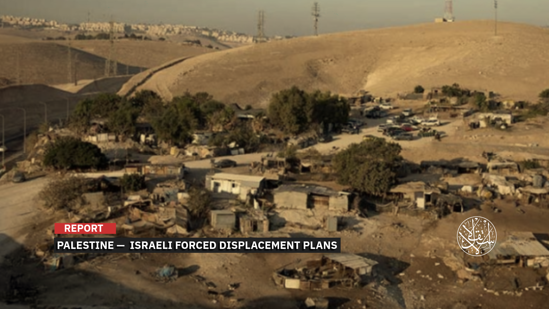
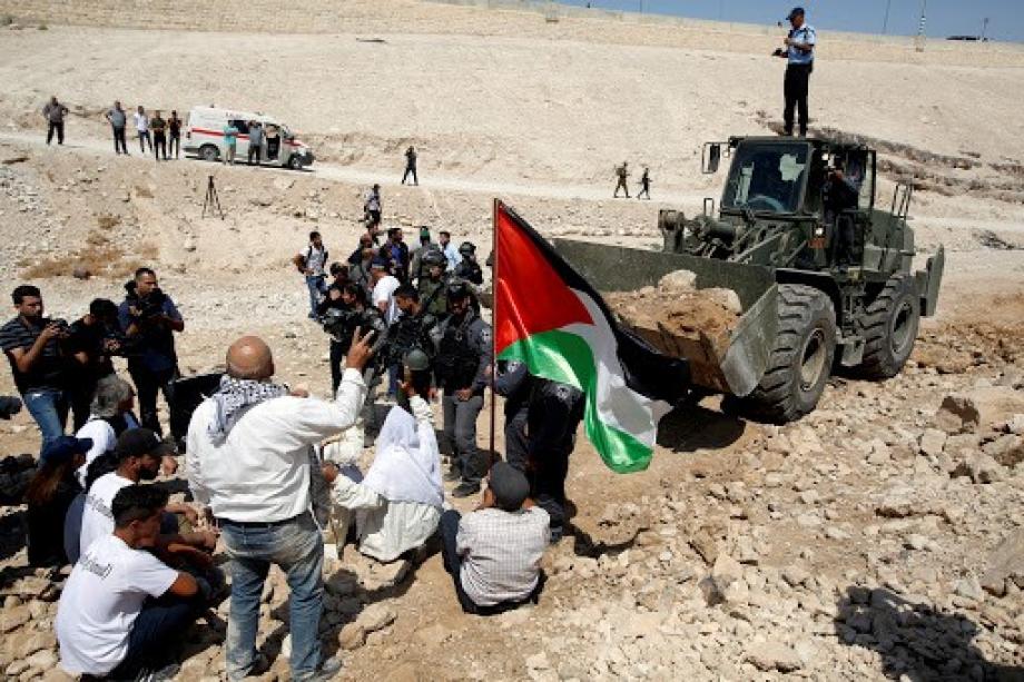
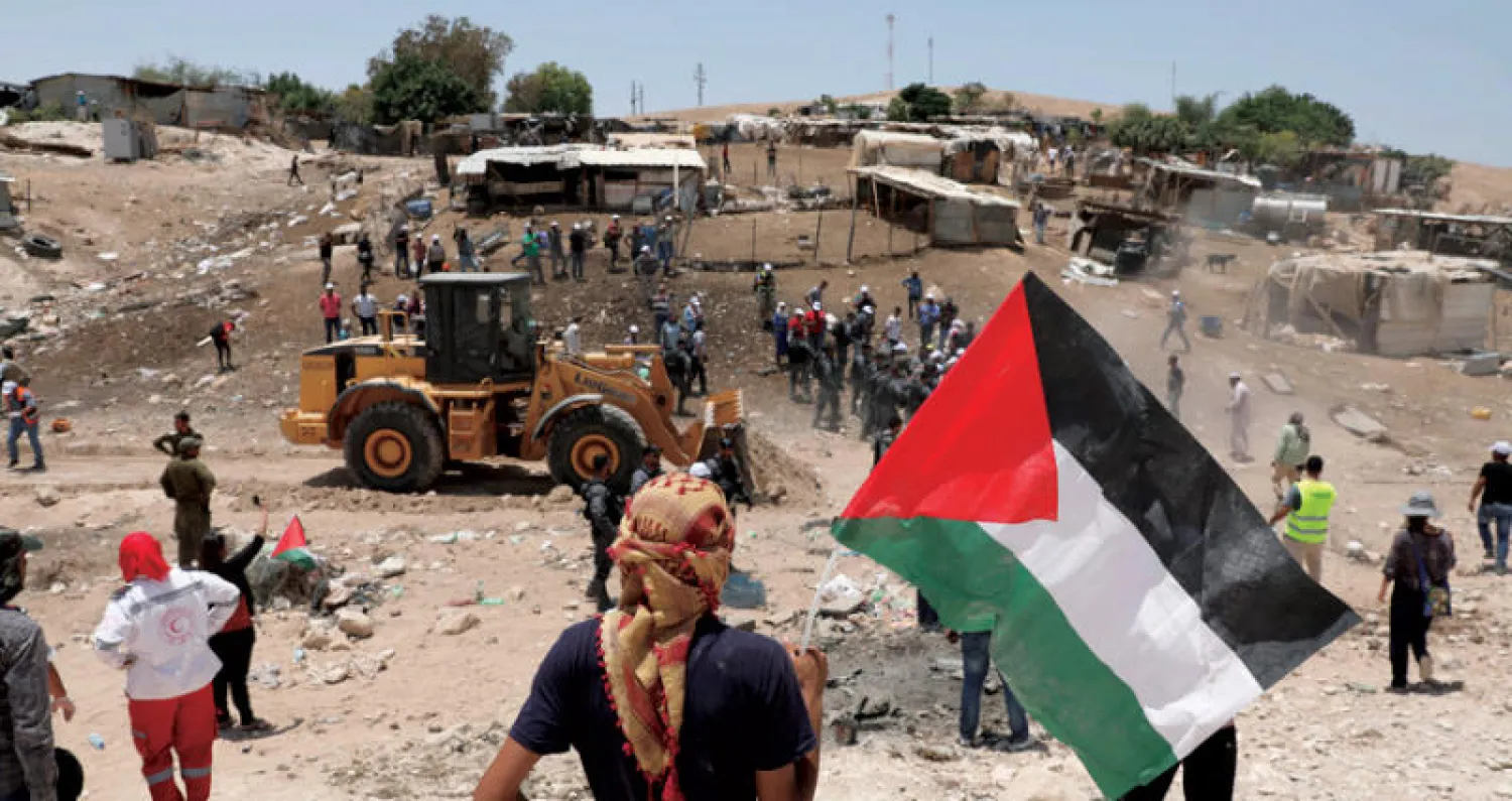
Perched on a dusty hillside between al-Quds and Jericho, a cluster of modest homes made of wood, tin, and tents forms the small Bedouin community of Khan al-Ahmar. The village is home to several Palestinian families who herd sheep across the eastern slopes of the occupied city.
In recent years, this remote outpost has become the focal point of a dispute that extends far beyond its borders. The community now faces the threat of forced displacement under an Israeli Occupation plan tied to settlement expansion, with authorities seeking to clear the area as part of the controversial “E1” project, which aims to link the settlement of “Ma’ale Adumim” to occupied “Jerusalem” (al-Quds).
The Khan al-Ahmar Story
The latest escalation came on May 19, 2026, when Israeli Finance Minister and Civil Administration Head in the War Ministry Bezalel Smotrich signed a directive calling for forcibly displacing the residents of Khan al-Ahmar “as soon as possible.”
It is still unclear when the directive will take effect, or whether it requires approval from the security cabinet or could face further legal challenges. Israeli anti-settlement groups have warned, however, that demolition of the community’s structures could become possible within weeks.
Smotrich’s move has brought the issue back to the forefront, especially after he signaled readiness to advance the displacement order amid reports that he could face an arrest warrant from the International Criminal Court (ICC).
The development has reopened the Khan al-Ahmar file not as a local demolition dispute but as a broader case involving longstanding demolition orders, a community resisting forced displacement, and a highly sensitive location under full Israeli Occupation control.
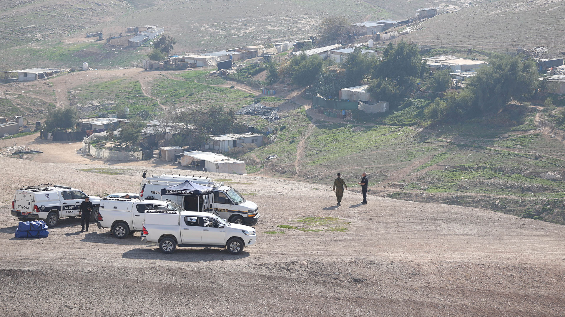
Khan al-Ahmar lies in Area C, about 12 kilometers east of al-Quds, and is made up of Bedouin families from the Jahalin tribe, originally displaced from the Negev in the 1950s and later expelled again from lands near “Kfar Adumim” in the 1970s before settling in their current location.
Today, around 45 families—roughly 320 people according to the Palestine News and Information Agency WAFA—live in the community. Israeli Occupation authorities argue that the structures are “unlicensed” because they were built in Area C.
Human rights organizations, however, say what is called the Israeli Civil Administration effectively prevents Palestinians from obtaining building permits, forcing residents to build without authorization and then face demolition orders.
The Bedouin residents refuse to leave, describing the plan as forced displacement that would uproot a pastoral way of life tied to the land and relocate them to areas that neither suit their livelihood nor preserve their right to remain.
The legal process used to legitimize the demolition began in 2009, when the settler organization “Regavim” filed a petition with the High Court demanding the demolition of Khan al-Ahmar.
After years of deliberation, the court ruled on May 24, 2018, allowing the Israeli Occupation government to demolish the village and relocate its residents to the Abu Dis area, a decision that laid the legal groundwork for demolition but was repeatedly delayed due to international pressure and human rights campaigns.
The Israeli Occupation government filed nine requests to postpone implementation until February 2022, all of which were granted, though the court stressed that the delays could not continue indefinitely.
Smotrich’s latest directive now pushes toward enforcing existing orders, effectively bringing a long-standing threat back into an active phase of preparation.
What Are Israeli Occupation Objectives?
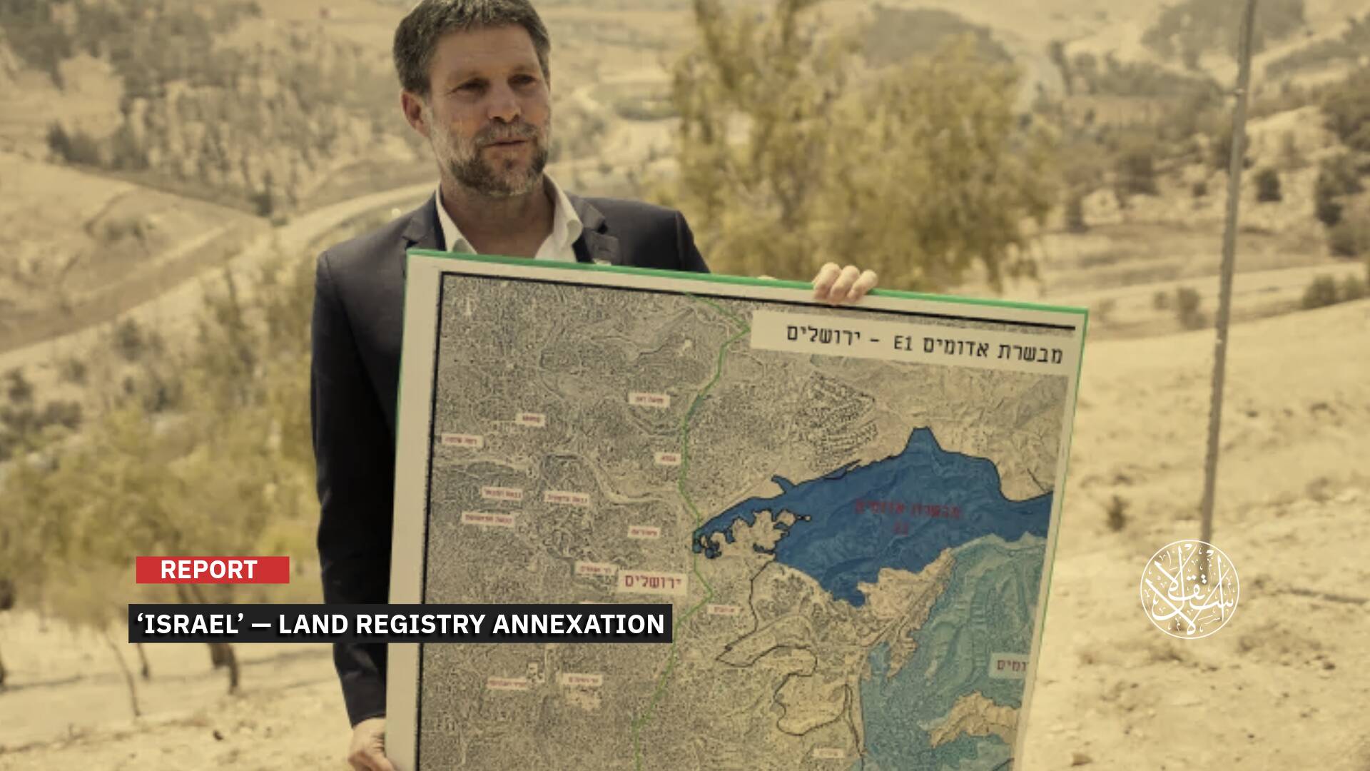
To understand “Israel’s” motives regarding Khan al-Ahmar, it is necessary to look at the map. The area known as “E1” lies on the western edge of the “Ma’ale Adumim” settlement and stretches over roughly 12 square kilometers between the illegal settlement and eastern al-Quds.
This is not a marginal stretch of land but a sensitive geographic junction between al-Quds and “Ma’ale Adumim.” It is precisely this corridor that “Israel” seeks to transform into a continuous settlement bloc linking the settlement directly to the city.
The continued presence of Khan al-Ahmar in the heart of this area preserves a Palestinian footprint in a space envisioned by Israeli authorities as an uninterrupted settlement corridor between occupied “Jerusalem” (al-Quds) and “Ma’ale Adumim.”
Through settlement construction and an expanding road network, the Israeli Occupation aims to establish direct territorial continuity between the settlement and al-Quds, while redirecting Palestinian movement onto alternative routes that bypass the area.
“Ma’ale Adumim” itself is one of the largest and most prominent Israeli settlements east of occupied “Jerusalem,” forming part of a broader strategy to create a settlement belt encircling the city and further isolating it from its Palestinian surroundings.
The “E1” project is not new. It has been advanced by Israeli Occupation governments since the 1990s but remained largely frozen under sustained U.S. and European pressure.
In August 2025, “Israel’s” Higher Planning Committee approved plans for 3,401 settlement units in the area, followed in December by an official tender inviting companies to submit bids.
This marks one of the largest single settlement expansions in recent years and forms part of a broader wave of construction approvals totaling 9,629 settlement units in 2025, more than half of them in “Ma’ale Adumim.”
Alongside settlement building, the Israeli Occupation government plans to construct what it calls the “sovereignty road,” referred to by Palestinians as the “apartheid road,” which would channel Palestinian traffic into a narrow bypass route around “Ma’ale Adumim,” potentially limiting or blocking access to the main road.
The road would provide Israeli Occupation settlers with a direct corridor between “Ma’ale Adumim” and occupied “Jerusalem” without passing through Palestinian areas.
At the same time, it would reinforce settlement contiguity from occupied “Jerusalem” toward “Ma’ale Adumim” and onward to the Jordan Valley, while reducing Palestinian connectivity to fragmented, non-contiguous transport routes.
What Forced Displacement Means
Forced displacement, if carried out, would mean far more than the removal of a cluster of modest homes. Most residents of Khan al-Ahmar descend from the Jahalin Bedouin tribe, which was itself displaced from its original lands in the Negev after the 1948 Nakba, and would now be forced to relocate again, most likely to an area such as Abu Dis.
The UN Office of the High Commissioner for Human Rights (OHCHR) says that the pressure to evacuate Khan al-Ahmar fits within a broader pattern of forced displacement and settlement expansion in the occupied territory.
The village is not an isolated case. It is one of 18 Bedouin communities in the so-called “E1” area, home to around 4,000 people, all of whom the United Nations says are directly affected by settlement construction plans between East “Jerusalem” and “Ma’ale Adumim.”
Since 2009, the OHCHR has documented the demolition of around 550 structures across these 18 communities, on the grounds that they lacked Israeli-issued building permits, including 175 structures funded by humanitarian donors.
For this reason, the displacement of Khan al-Ahmar’s residents could set a practical precedent, paving the way for increased pressure on neighboring communities, particularly those located near planned road routes or within designated settlement expansion zones.
These include communities such as Wadi el-Jamil near the planned “sovereignty road” and Jabal al-Baba in the vicinity of al-Eizariya and Abu Dis, raising the prospect of entire communities losing both their homes and their pastoral way of life.
Other communities such as Wadi Sneysel, Bir al-Maskoub, and Abu Nuwar are located within the same geographic corridor between Route 1, “Ma’ale Adumim,” and the eastern outskirts of occupied “Jerusalem.”
On the map, the project would further isolate East “Jerusalem” from its Palestinian surroundings, undermining natural access to the city and weakening the possibility of making it the capital of a future Palestinian state.
It would also fragment geographic continuity between the northern and southern West Bank, turning the territory into a series of disconnected “cantons” and making the idea of a viable Palestinian state increasingly difficult to sustain.
Beyond geography, humanitarian organizations warn that residents of these threatened communities risk losing their livelihoods as well as access to essential health and education services.
This fragmentation is expected to deepen poverty levels and erode the pastoral culture that forms a core part of the identity of Bedouin communities on the eastern slopes of occupied “Jerusalem.”
Amid all this, the Israeli Occupation government is facing growing international opposition. A joint statement by several Western countries in May 2026 described the “E1” project as illegal and warned that it would split the West Bank, while the European Union and other states said the project undermines the two-state solution and called on “Israel” to reverse course immediately.
The UN human rights office has also called on the Israeli Occupation to halt displacement measures in Khan al-Ahmar and stop settlement expansion in “E1,” saying the two processes are directly linked: the removal of Palestinian communities on one hand and the consolidation of a new settlement reality on the other.
Sources
- Minister Smotrich Orders the Evacuation of Khan al-Ahmar as Part of Israeli Takeover of the Central West Bank and Construction in E1
- Urgent: Al-Haq Calls for Immediate International Action to Protect Khan al-Ahmar and the Palestinian People from Collective Punishment
- Communities facing expulsion: The Khan al-Ahmar area
- Israeli court approves razing West Bank Bedouin village
- Israel must halt forcible displacement of Khan Al Ahmar and settlement expansion in E1 [EN/AR]
- Joint statement on the Occupied Palestinian Territories