Satellites in War: From Surveillance Tool To Narrative and Strike Weapon
Planet Labs owns the largest Earth imaging fleet in history.
At the moment when Iranian strikes expanded to hit critical U.S. and Israeli military sites, satellite images were no longer just tools for journalistic tracking or visual documentation; they became active elements in the deterrence equation itself.
In this context, the decision by the U.S.-based company Planet Labs, announced on March 10, 2026, to extend the delay for accessing images of the Middle East from four days to 14 days, went beyond commercial considerations and directly intersected with national security concerns.
The Washington Post reported on March 11 that Planet Labs and another major commercial imagery provider, Vantor, imposed restrictions on access to images of the region during the American-Israeli war on Iran.
Both companies stated that the decision was not issued by the government directly but was taken independently.
However, the wording Planet Labs used in its message to clients carried deeper implications than a simple denial, clarifying that the goal was to prevent tactical use of the imagery by hostile actors to target NATO allies, partners, and civilians.
This implicitly acknowledged that commercial satellite imagery was no longer outside the battlefield; it had become part of it.
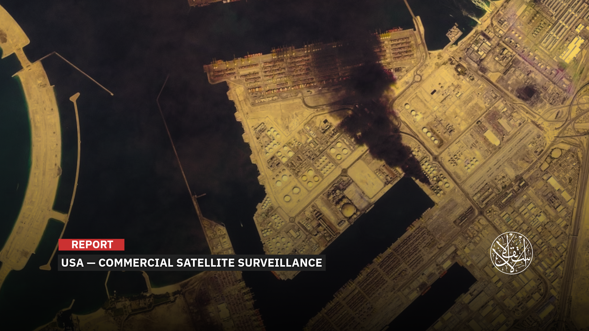
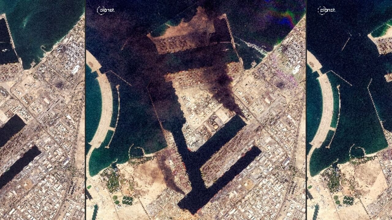
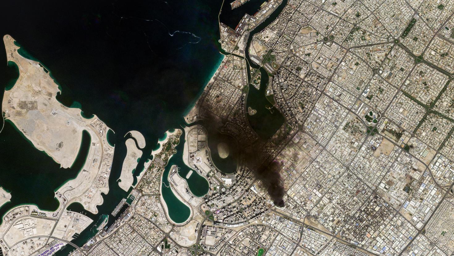
This shift did not happen in a vacuum. Satellite images, cited by The Washington Post, Associated Press, and other media during the first days of the war, revealed damage at sensitive sites.
The damages included a school in Minab, southern Iran; a U.S. naval base in Bahrain; Ali al-Salem Air Base in Kuwait; later images showed destruction at the U.S. Fifth Fleet headquarters in Bahrain and damage to al Dhafra Air Base in the UAE.
Images also captured fires at Dubai Airport and the Port of Salalah in Oman, making the flow of imagery itself part of the conflict over revealing losses and gauging the extent of Iranian incursions.
At this point, Washington began to see “space transparency” as a double-edged weapon: it exposes the adversary’s movements while simultaneously revealing the damage inflicted on allies and what could be targeted in subsequent escalation rounds.
Thus, the story of Planet Labs is not just about a commercial company’s decision; it reflects a deeper transformation in the role of imagery in wartime, shifting from a visual archive to raw intelligence used for analysis, assessment, and building a more precise target database, especially as the scope of targets expands to military bases, logistical routes, ports, airports, and energy and communications infrastructure across the Gulf and Eastern Mediterranean.
Major Company
What makes Planet Labs exceptional is not only that it is a major U.S. company, but that it represents a fully developed model of how commercial space has transformed into an almost daily surveillance system.
According to its official data, the company operates around 200 Earth-imaging satellites and claims to have the largest imaging fleet in history, asserting that this constellation can capture the planet’s landmass on a daily basis.
This capability is not limited to taking static images; it represents a qualitative shift in understanding time on the battlefield, allowing continuous monitoring of changes and comparisons from day to day, or sometimes even hour to hour, in a fast-changing operational environment.
The company’s value, therefore, is no longer measured merely by image resolution, but by the frequency and continuity of its coverage, tracking the movement of a ship, repositioning of aircraft, effects of a strike, or emergency logistical activity around a military base or strategic port.
This aspect led Reuters to note that the expansion of the commercial space sector has reshaped the nature of modern conflicts, as imagery is no longer exclusive to governments but available to media companies, researchers, and private intelligence institutions.
Importantly, Planet Labs is no longer a purely civilian company in the traditional sense. On October 16, 2025, it announced via Business Wire that it had secured a $12.8 million preliminary contract with the U.S. National Geospatial-Intelligence Agency (NGA) to provide AI-powered maritime awareness solutions, including ship detection and tracking.
Earlier, on June 12, 2025, the company revealed that NATO had selected it under a multi-million-dollar contract to provide daily monitoring, early warning, and enhanced maritime situational awareness from space.
Thus, Planet Labs has evolved from being merely an imagery provider to a strategic actor in the Western security architecture, combining commercial technology with intelligence functions simultaneously.

Commercial and Military
These contracts do not mean that Planet Labs merely sells images; they indicate that its data has become part of the intelligence analysis and early-warning layer within the Western security apparatus.
When combined with its recent decision to delay image releases, it becomes difficult to separate the commercial and military dimensions of its business model.
Although publicly traded, the company simultaneously serves as an authorized provider for Western security and military entities, with daily monitoring capabilities that Washington may not always wish to reveal as quickly, whether to adversaries, media outlets, or markets.
Thus, the decision to restrict access is not only about denying opponents the benefit but also about controlling the timing of damage disclosure, preventing imagery from instantly revealing the scale of strikes on military bases, airports, oil facilities, or defense infrastructure.
Even from a purely commercial perspective, The Economist noted that some clients of commercial intelligence and corporate customers expressed concern over their sensitive Gulf facilities becoming visible targets in an open market accessible to a wide subscriber base.
Planet Labs has therefore evolved from a successful company into a model of an entity with “small-state” surveillance capabilities, while lacking the luxury of remaining outside the geopolitical calculations of major powers.
Washington’s challenge is not limited to the company itself but extends to the open environment in which it operates. An adversary like Iran does not necessarily need to purchase the service directly to benefit from it.
Reuters reported that space experts believe images could reach Tehran through third parties or other U.S. adversaries, at a time when image analysis capabilities are rapidly increasing thanks to AI and civilian tools.
The Economist also noted that some researchers were unable to access imagery of the Iranian coast that had been available days earlier, indicating broader concerns about networks of intermediaries and secondary data providers, which could act as indirect channels for information transfer.
Nonetheless, Iran’s surveillance efforts do not start from scratch; fixed targets such as ports, bases, energy centers, certain runways, and logistical facilities can be monitored to varying degrees using civilian tools and open mapping platforms.
What commercial satellite imagery adds is the decisive layer: continuously updated information, real-time assessment of moving or changing targets, such as ships, ground convoys, aircraft redeployments, or air-defense system movements.
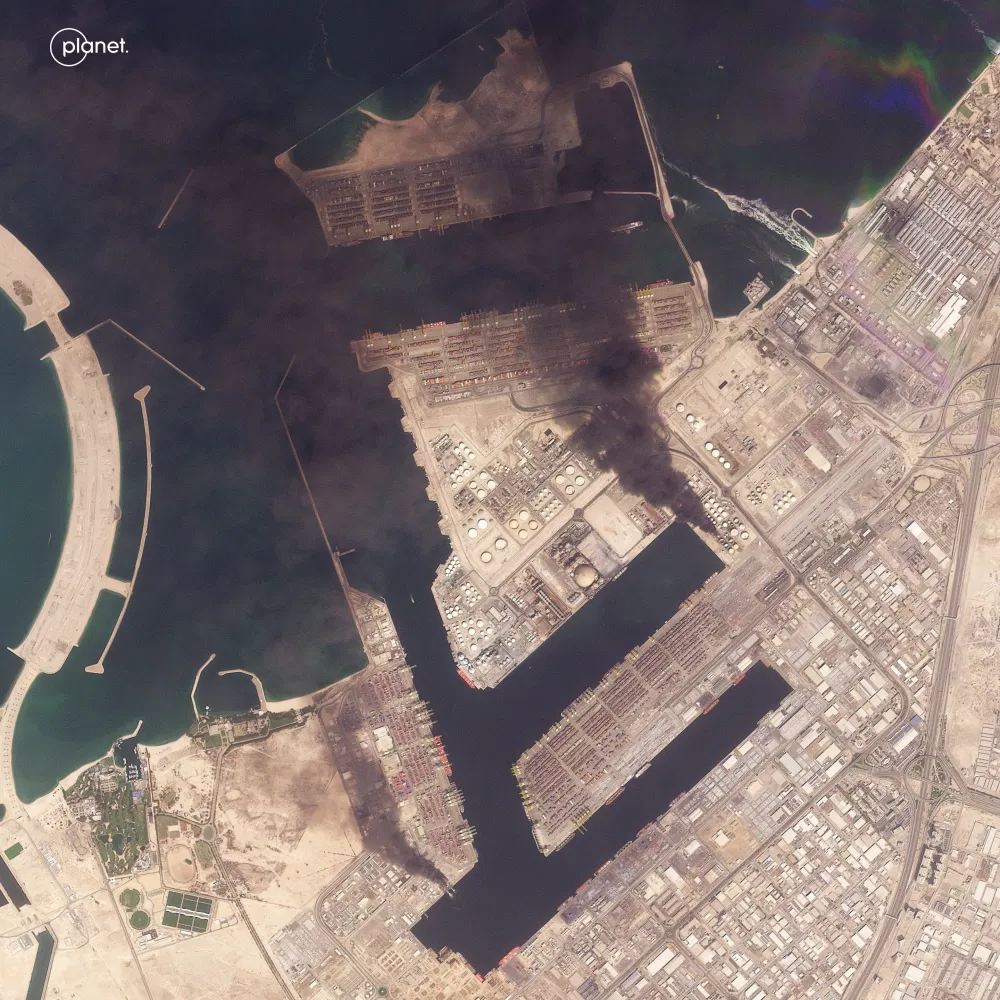
Image Restrictions
Imagery gains multiplied military value when integrated with signal intercepts, maritime and aerial tracking data, or even publicly posted materials on networks.
This is precisely why journalism and open-source investigation organizations have strongly objected to image-restriction decisions.
The Global Investigative Journalism Network (GIJN) cited Carlos Gonzalez, head of research at Bellingcat, a platform specializing in open-source investigations (OSINT), who said real-time images are essential for verifying the scale of damage, locating strike points, and cross-checking eyewitness reports.
Gonzalez referenced the strike on the Minab school, emphasizing that withholding imagery from adversaries simultaneously restricts journalists and investigators, limiting independent verification and giving military actors greater control over the narrative.
This warning aligns with The Economist, which noted that image restrictions could foster the spread of manipulated images and AI-generated content, as the absence of reliable original material increases the risk of misinformation and reduces fact-checking capabilities.
Specifically regarding Iran, Tehran appears to benefit from this complex environment; it does not rely on a single provider or channel but on a mix of open markets, open-source analysis, intermediary networks, and non-Western alternatives.
Herein lies Washington’s real dilemma: it can delay access to Planet Labs imagery, but it cannot close the skies entirely or prevent a flexible adversary from constructing an approximate view of the battlefield using fragmented intelligence.
This challenge becomes even more acute in a geographically and operationally expanding war, stretching from strikes on U.S. bases to deep inside “Israel,” where every hour of information becomes a critical factor in operational calculations.
Monopoly Broken
However, while Planet Labs exposed the limits of U.S. control over the commercial imagery market, China has revealed the limits of U.S. control over the commercial space sector itself.
Chinese companies such as Jilin-1 and Siwei are expanding their Earth-imaging operations just as American firms begin restricting access to images of the Middle East.
This is not merely a technical detail, it represents a significant strategic shift. The Chinese alternative is not just a commercial competitor; it also serves as a potential data source at the exact moment Western channels are closed or restricted.
More tellingly, a report by FlightGlobal highlighted the activity of a Chinese geospatial intelligence firm, Mizar Vision, which publicly published images and analyses tracking U.S. and Israeli military assets, from aircraft carriers to F-22 fighters and airbases in the Gulf, some of which were later struck by Iranian forces.
The report notes that there is no conclusive public evidence that Tehran directly used these images, but it emphasizes a more critical point: major militaries can no longer easily conceal their heavy assets amid a growing network of commercial observers, including Chinese firms with advanced imaging and analytical capabilities.
China thus enters the equation on two parallel fronts: competing in the market and providing potential alternatives for states or actors unable to rely on Western providers.
This is not just a matter of competition or even a covert partnership; it is closer to a redistribution of influence in the global commercial intelligence market.
According to Reuters, the tighter American restrictions become under the pretext of protecting allies, the greater the geopolitical value of Chinese companies capable, implicitly, of offering a different model that does not restrict imagery flow to the same extent.
At this point, U.S. blocking loses part of its effectiveness: prohibitions do not eliminate demand, they redirect it toward alternatives.
This new reality means that while Washington may partially reduce its immediate exposure, it simultaneously pushes users, researchers, and even some security and commercial clients toward non-American platforms.
With the expanding role of artificial intelligence in image analysis, superiority is no longer limited to those capturing the highest-resolution shots, but to those capable of providing repeated coverage, rapid delivery, and advanced analytical systems that can integrate multiple data
Sources
- Satellite Companies Restrict Access to Middle East Imagery Amid Iran War
- The Fate of Satellite Images Reveals Bases and Missiles [Vietnamese]
- Satellite Firm Extends Middle East Image Delay to Prevent Use by U.S. Adversaries
- Access to Satellite Imagery Restricted Amid Iran War: Report
- Open-Source Intelligence Shuts Down