Turkiye’s Devastating Earthquake: How Does It Reflect the Future of the Middle East?

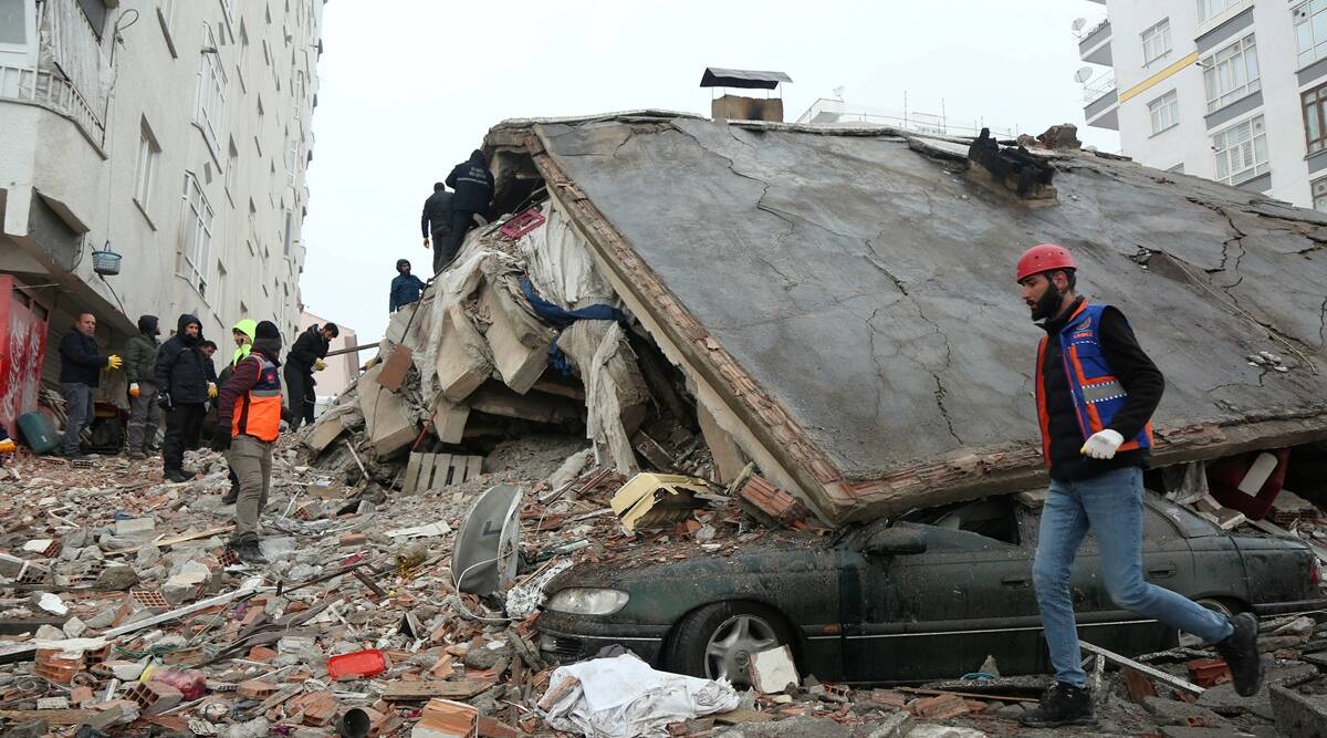
The devastating earthquake of February 6, 2023, not only destroyed 10 Turkish cities and some others in northern Syria but also destroyed the entire Middle East, according to Arab and foreign scientists and geologists.
Monday’s magnitude 7.8 quake cut a swath of destruction that stretched hundreds of kilometers across southeastern Turkiye and neighboring Syria.
The effects of the two earthquakes also extended to areas nearly a thousand kilometers from Turkiye, including Iraq, Lebanon, Cyprus, Jordan, Egypt, and the Israeli Occupation.
With the return of the activity of what is known as the “East Anatolian Fault” after relative inactivity for many decades, geologists expect that the Middle East region will witness other earthquakes in the future, which may cause great damage and affect the future of the region.
These warnings were published as early as June 2012 in the American Journal of Geophysical Research, which confirmed the dangers of a continuous widening of the East Anatolian Fault, putting the Middle East region in front of an expected series of devastating earthquakes.
Anatolian Fault
A fault is a fracture or zone of fractures between two blocks of rock. Faults allow the blocks to move relative to each other. This movement may occur rapidly, in the form of an earthquake—or may occur slowly, in the form of creep.
An earthquake is what happens when two blocks of the earth suddenly slip past one another. The surface where they slip is called the fault or fault plane.
Three seismic lines are active within Turkey’s borders, according to the Arabic-speaking Turkish television website TRT Arabi on February 6, 2023:
The first is the West Anatolian Fault, the most mobile, and passes through the regions of the Aegean Sea and the Sea of Marmara.
The second is the North Anatolian Fault, 1,350 kilometers long, passing through the areas opposite the Black Sea, all the way to the bottom of the Sea of Marmara in the west.
The last is the East Anatolian Fault, with a length of 530 km, starts in the city of Hatay and ends in the city of Mus, and the northern and eastern faults meet in the city of Bingol.
Geologically, Turkiye is surrounded by three tectonic plates (the solid rocky layer that surrounds the globe), namely the Arabian and African plates to the south and the Eurasian plate to the north.
Therefore, Turkish cities are located within a seismically active geographical area where the movement of tectonic plates in the eastern Anatolian Fault generates great seismic activity.
This makes the area one of the most earthquake-prone in the world and the type that causes widespread damage due to its proximity to the surface.

In the Earth’s interior, there is a huge network of faults tearing the earth’s lithosphere and completely surrounding it.
Scientists confirm that the earth under our feet is completely unstable, consists of layers of varying thickness moving in different directions, and is full of cracks and fractures permeated by narrow streams of fluids.
There are sediments, mud, and rock bases, unlike those giant tectonic plates that rub against or diverge from each other.
The Earth was “a hot core” like the rest of the planets, and when it cooled, the hydrosphere was formed and attracted the atmosphere. With the cold increasing, the outer solid layer known as the crust was formed, but the interior of the earth remained hot until now, and it is a plastic, semi-molten layer of high viscosity and temperature.
The Earth’s lithosphere, or crust, is made up of 12 plates, or what are known as tectonic plates.
These panels float above the molten core, and when the earth rotates on its axis in front of the sun, it causes these panels to slip over this viscous layer, which sometimes leads to the separation of the panels due to lava flows rising from the bottom up.
In areas where lava flows fall, some of these panels collide with each other and lead to earthquakes.
The irony was that the Dutch geologist and seismologist Frank Hoogerbeets literally predicted an earthquake of this magnitude for the eastern Anatolian Fault line 3 days before the catastrophe.
On February 3, the expert predicted the location and intensity of the earthquake with great accuracy, saying: “Sooner or later there will be a ~M 7.5 earthquake in this region (South-Central Turkey, Jordan, Syria, Lebanon).”
He published the earthquake map as he predicted, despite scientific theories confirming that predicting earthquakes is impossible.
Sooner or later there will be a ~M 7.5 #earthquake in this region (South-Central Turkey, Jordan, Syria, Lebanon). #deprem pic.twitter.com/6CcSnjJmCV
— Frank Hoogerbeets (@hogrbe) February 3, 2023
Dangerous Area
After the earthquakes that Turkiye was exposed to, the fault lines there returned to the fore again, bringing many questions about what happened.
The Pledge Times website stated that Turkiye’s presence between the Arab and Eurasian plates leads to pressure on the region and makes the fault lines more destructive.
Historically, the East Anatolian Fault caused a series of earthquakes that began with the Antioch earthquake in 1822, continued with the earthquakes of 1866, 1872, 1874, 1875, and 1893, and ended with the Malatya earthquake in 1905.
The East Anatolian Fault entered a quieter period, except for the 1971 Bingol earthquake.
But with the new 6.8-magnitude earthquake in Elazığ province on January 24, 2020, the East Anatolian Fault Line moved from inactivity to activity again.
Since 1500, Turkiye has suffered more than 23 earthquakes of +7 magnitude (considered as dangerous), according to the Anadolu Agency on February 6, 2023.
The August 17, 1999 earthquake in İzmit, northwest of the country, with 7.4 degrees, 17,118 deaths, and more than 25,000 injured, was the last of the most dangerous of these earthquakes.
It was followed by the Duzce earthquake (a 7.2-magnitude) on November 12, 1999, which killed 894 people, then the Van Earthquake in 2011 (7.2 degrees) on October 23, 2011, that killed 601 people, then the February 2023 earthquake.
Seismologists confirm that the 7.8 quake that struck Turkiye and Syria on February 6, 2023, with a magnitude of 7.8, was among the deadliest in recent world history, with a more than 100 km (62 miles) rupture between the Anatolian and Arabian plates.
“The shaking at the ground surface will have been more severe than for a deeper earthquake of the same magnitude at source,” David Rothery, a planetary geoscientist at the Open University in Britain, said.
Middle East Earthquakes
While the Arab countries are preoccupied with their conflicts on the ground, such as wars and epidemics, natural disasters have begun to emerge from underground, represented by an alarming increase in seismic activity in several regions of the Middle East and North Africa.
Dr. Judith Hubbard, an earthquake and plate tectonics expert at Harvard University, wrote a series of tweets on Twitter explaining the seriousness of the consequences of the Turkiye earthquake.
She emphasized that this earthquake is abnormal and one of the largest recorded earthquakes because it results from the movement of the Arabian plate towards the Eurasian plate and thus increases the movement of the Anatolian Fault by 5 meters and crushes the earth’s crust between the converging plates.
She explained that “the Arabian Plate is colliding northward with the Eurasian Plate. The East & North Anatolian faults work together: they allow the Anatolian block to squeeze westward out of the collision zone, like a watermelon seed out from your fingers.”
In the case of the current earthquake, the Arabian plate was moving north and grinding in its friction the Anatolian plate, which increases the devastating earthquakes that move to the Middle East.
She said, “GPS shows that across the East Anatolian Fault, the blocks are moving ~15 mm/yr relative to each other. That motion stretches the crust across the fault. A M7.8 earthquake might slip ~5 m on average. So today’s quake is catching up on about 300 years of slow stretching.”
Today's M7.8 earthquake in Turkey occurred in the East Anatolian Fault zone.
— Dr. Judith Hubbard (@JudithGeology) February 6, 2023
Although this fault is a known hazard, the quake is unusual. Today's M7.8 released >2x as much energy as the largest recorded quakes in the region (M7.4).
Image credit: Kyle Bradley
1/ pic.twitter.com/c7Kwt03Ivf
Dr. Salah Mahmoud, former head of the Egyptian National Institute for Astronomical Research, believes that all regions bordering the Mediterranean are vulnerable to earthquakes as a result of the rapprochement between the African and European continents.
Mahmoud added to the American Alhurra website on February 6 that countries such as Cyprus, Greece, northwestern and southern Turkiye, Algeria, and Morocco may witness earthquakes as a result.
The Egyptian geological expert, Dr. Yahya Kazzaz, confirms that the continuation of the collision of the North African faults (the Arabian plate) with the Eurasia fault and its pressure on the Anatolian Fault will cause further earthquakes in the region.
He told Sky News on February 6 that when the two faults meet, earthquakes occur, as the continent of Africa moves towards southwestern Europe and part of Asia.
He added that this movement would lead, over millions of years, to the closure of the Mediterranean Sea when the African and European plates converge, and the large number of earthquakes in the region is evidence of the process of subduction between the plates and the slipping of the earth’s crust.
The geologist expected that earthquakes would recur periodically in this geographical area because it is within a seismic belt.
According to the Euro-Mediterranean Seismological Center, the number of medium and large earthquakes (magnitude between 4 and 8), which occurred during 2022, amounted to 103, of which 40 were in the eastern Mediterranean and 21 in the western one.
Sherif El-Hadi, head of the seismology department at the National Institute for Astronomical Research in Egypt, said: “The Mediterranean region in general regularly witnesses earthquakes that are not announced because they are weak; only medium- and large-sized earthquakes are usually announced.”
On January 24, 2022, the Risk Forecast Department at the Arabian Gulf Center for Studies and Research monitored a disturbing development of seismic activity in the Middle East region in particular.
It emphasized that nearly 30 million people in the Middle East, equivalent to one-fifth of the Arab population in the Middle East and North Africa regions, are exposed to increased risks of devastating earthquakes in the future.
The center’s monitoring relied on studying the global seismic hazard map by collecting data and models for the frequency of occurrence and assessing the risks of earthquakes in the Middle East region.
In 2020, a study by researchers from the Israeli Tel Aviv University concluded that a devastating earthquake of 6.5 degrees on the Richter scale is expected to hit the Middle East, specifically the Dead Sea countries, in the near future.
Jerusalem Post newspaper said on December 30, 2020, that the study published in Science Advances magazine found that a devastating earthquake strikes the region every 130 to 150 years.
If the last strong earthquake to hit the region was 93 years ago, the researchers expect “a similar event in the near future.”
Scientists warn that the great seismic activity in the Anatolian Fault may affect the Dead Sea Fault because it extends from Kahramanmaras, the epicenter of the devastating earthquake, to the Gulf of Aqaba.
Sources
- An area with high risk of seismic movements
- Explainer: Why was the Turkey-Syria earthquake so bad?
- What is the story of the eastern Anatolian fault, and what are the most severe earthquakes that have historically struck the region? [Arabic]
- Israel to be soon hit by a destructive and deadly earthquake, study shows